Upper Mustang Trek
Difficulty:
Duration : 21 days
Season: Autumn / Summer / Spring
Highlights of the trek
Mustang, the former Kingdom of Lo, is an isolated region of the Nepalese Himalayas, renowned for its preserved Tibetan culture and spectacular landscapes. Long closed to foreigners, it was opened to trekking only in 1992, making it today one of the most authentic regions of Nepal.
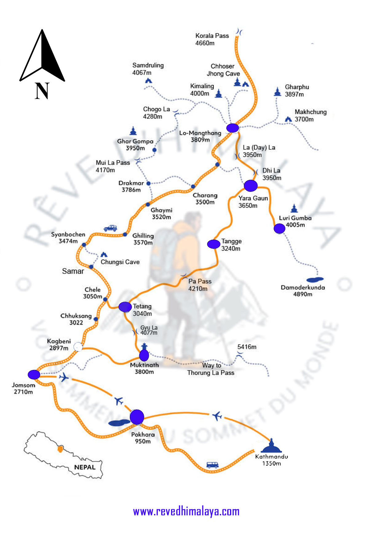
The Upper Mustang trek crosses the northern part of the Mustang District, along the river, following an ancient trade route between Tibet and India. The landscapes alternate between high-altitude deserts, colorful cliffs, deep gorges, and Himalayan peaks, offering a unique immersion in a pristine and mineral-rich environment.
This trek provides an in-depth discovery of Tibetan Buddhist culture through traditional villages and ancient monasteries. Lasting approximately 21 days, it is ideally undertaken from April to November, including during the monsoon season. Accessible from Jomsom, the trek requires a special permit and is suitable for hikers in good physical condition, with accommodation in lodges during the trek and in hotels in Kathmandu and Pokhara.
Upper Mustang Trek
Detailed Itinerary
Day 01: Arrival in Kathmandu (1300m/4264ft)
After arriving in Kathmandu, a representative from Rêve d’Himalaya Trekking will pick you up at the airport and take you to your hotel. In the afternoon, there is an opportunity for a rest after your long flight.
Day 02: Kathmandu: sightseeing and trek preparation
After breakfast we offer a guided tour to two of a selection of several of the most historical and spiritual attractions in Kathmandu which are also listed as UNESCO World Heritage sites. You can chose between the historic Durbar Square, the sacred Hindu temple of Pashupatinath, the famous ‘Monkey Temple’ (Swayambhunath) and Buddhist shrine (Bouddhanath), which hosts also one of the largest stupas in the world. In the afternoon, there will be a pre-trek meeting where you can meet your trek leader and other team members. Rêve d’Himalaya Trekking will brief you regarding details of your trek and provide you with an opportunity to ask any questions you may have regarding our upcoming adventure.
Day 03: Drive or fly to Pokhara (804 m / 2,755 ft)
There are two options to reach Pokhara, the second biggest city of Nepal. By bus from Kathmandu it takes about 6 hours. Flying from Kathmandu to Pokhara takes just 25 minutes, but the flight schedule is at times dependent on weather conditions. Overnight stay at a hotel in Pokhara.
Day4 : Flight to Jomsom (2,710m / 8,892 ft) and trek to Kagbeni (2,800m / 9,187ft): 3 hours trek
You take an early morning flight (20 minutes) in a small aircraft. It will provide you with close-up views of the Annapurna range, the Dhaulagiri and nearby satellites peaks. Upon arriving, you will start your hike by leaving Jomsom northwards. You cross a small hanging bridge and then proceed along the banks of the Kali Gandaki on a flat rocky but easy-going trail until reaching the pretty village of Kagbeni, the gateway to Mustang. On your way, you enjoy picturesque views of big peaks all around such as Dhaulagiri (8,167m / 26,794ft), Tukuche (6,920m / 22,703ft) and in the west the awesome mountain above Kagbeni, Nilgiri 6,940m / 22,769ft). Over to the south and south-west the entire Annapurna massif can be seen. You are more than likely to meet Indian pilgrims on their way to and from Muktinath on this stretch. About 80 families live in Kagbeni, most of them are traders who form the link between modern Nepal and the Tibetan-type region of Mustang. The settlement gives you a taste of scenes to come in Upper Mustang: narrow streets, a large red gompa and views of the surroundings of green fields of wheat and barley and their irrigation canals- Overnight stay in Kagbeni,
Day 5 : Kagbeni to Chhuksang (2,980m /97,77ft ) : 5 hours trek
You leave Kagbeni passing a police check-post at the northern end of the village. It is here that the restricted area begins, and you will have to show your special permit, While waiting for your papers to be processed, you can have a look at a very interesting information post with displays of Mustang artifacts and photos. Once cleared, you engage in a trail which heads along the right bank of the Kali Gandaki River. You approach and cross a riverbed farm which looks like an irrigating oasis. After several hours of hiking you stop for a much needed lunch break in Chhuksang village. You will see some pretty thatched houses built from mud walls and whitewashed outside. Overnight stay in Chhuksang.
Day 6 : Chhuksang to Samar (3,660 m /12,008ft ) – 4 hours trek
As of Chhuksang, you will notice a change not only in the topography, but also in the culture, lifestyle and people. The settlements become more scattered, smaller and are more basic. The people of Lo or Mustang practice agriculture, but because of the lack of rain and fertile soil, cultivation is in sheltered plots of land, scattering in the brown landscape as patches of green. You carry on northwards until you reach a huge red chunk of rock that has fallen from the cliffs above, forming a tunnel through which the river flows. A steel bridge spans the river just in front of the tunnel. It is no longer possible to follow the banks the Kali Gandaki. The trek now leaves the valley and climbs steeply up a rocky alley to the village of Chele. Watch out here for the ferocious Tibetan mastiffs which are chained to many of the houses. From Chele you climb up a steep spur and then continue ascending along the side of a spectacular steep canyon to a pass from which you descend on a pleasant trail to Samar, situated in a grove of poplar trees. This is a major stopping place for horse and mule caravans. Overnight stay in Samar.
Day 7 : Samar to Gheling (3,570m / 10,89ft) - 5 hours trek
You leave Samar and climb up a ridge. The trail then descends into a large gorge. You pass a chorten before entering another valley with juniper trees. You then cross a stream and after climbing to a pass, you descend along a ridge to Shyangmochen, a tiny settlement with a few tea shops. Nearby is Rangbyung, a cave containing stalagmites which have taken the shape of chortens. This is one of the holiest places in Mustang. The trail climbs gently as you leave Shyangmochen. You enter another huge valley and descend to Gheling with its numerous fields of barley. As in all the settlements of Mustang, the white and ochre-painted houses are constructed using mud and stones, with roofs made of twigs, straw and a mixture of mud and pebbles. Overnight stay in Gheling.
Day 8 : Gheling to Ghami (3,520m/11,548ft) - 5 hours trek
From Gheling the trail climbs gently through fields, up the center of the valley, passing above the settlement of Tama Gun and imposing chortens. Reaching the end of the valley, you begin a hard climb to reach the Nyi La pass (3840m / 16.600ft ). The descent on the other side is quite soft and you soon reach a trail junction; the right trail is the direct route to Charang, the left trail which you take leads to Ghami, a large white-washed village sheltered by overhanging cliffs. Overnight stay in Ghami.
Day 9 : Ghami to Charang via Ghar Gompa (3,560m/11,680ft) - 5 hours trek
After leaving Ghami the trail alternately descends and ascends through colorful cliffs and green landscapes. You reach the valley of Drakmar. There are lots of cliff caves above the village with colorful hillocks. After passing Drakmar you get a chance to see blue sheep while climbing towards the Mui La pass (4170m / 13,682 ft ). You reach the Ghar Gompa, the oldest monastery of Nepal which was built even before Samey Monastery of Lhasa (Tibet). This monastery is run by the Ngyinmapa sect. It is here that the hidden scriptures of Padmasambhava were said to be found. You later follow the Tsarang Khola river via Lo Ghekar to reach Charang / Tsarang. Ovrnight stay in Charang.
Day10 : Charang to Lo Manthang (3,840m / 12,599ft )- 5 hours trek
You will spend part of the morning exploring the interesting village of Charang and its large monastery, before setting out for Lo Manthang. You climb gently above the valley towards a large isolated chorten that marks the boundary between Charang and Lo. The trail then broadens and eventually you get your first view of the walled city of Lo Manthang, the capital of Mustang. The city has only one entrance so you have to walk around the city to the find the gate on the north eastern corner. Overnight stay in Lo Manthang
Day11 : Excursion Day in Lo Manthang
The whole day will be available to explore this ancient capital. Lo Manthang is untouched since the 14th century. The city comprises about 150 houses, as well as residences for its many lamas. There are four major temples within the city and one of these, Champa Lhakang, contains a huge clay statue of Buddha as well as elaborated mandalas painted on the walls. The king’s palace is an imposing building in the center of the city and is occupied by the current King and Queen. Although his role today is largely ceremonial, the King is respected by the people and consulted on many issues by villagers throughout the kingdom. Overnight stay in Lo Manthang
Day 12 : Lo-Manthang to Chhosser caves: optional by horse or jeep
You will reach the Chhosser caves ridding by horse (optional: by jeep) and carry self-packed lunch. Chhosser is a mysterious place, by the beauty of its natural architecture. The cave looks like cliff but inside it there are step by step several floor with 44 rooms. This cave is so amazing that it gives the feeling of being in alien place. Return back to and stay overnight in Lo-Manthang.
Day 13 : Lo-Manthang to Yara (3,838m / 12,591ft) - 5 hours trek
From Lo-Manthang a short climb takes you up to a glacial valley with views to reddish brown historical wall city (the rainshadow zone) when looking back. From here, you enjoy an unforgettable impression of the walled city. Coming up to the hill, you cross the valley to reach the opposite side. Proceeding along the mountain ridge for about one hour the trail descends down to the village of Dhi. On your way, you will see the meadows and farming fields nearby the river side. Reaching Dhi village you will enjoy a lunch break. After some rest, you cross a river to follow a path along the left bank towards Yara village at (3,838m / 12,591 ft ). During the dry season the trail can follow the riverbed but in the monsoon one has to wind up the hills with a final steep climb to the top of the Yara hills. You have the impression of looking upon a natural sandy castle in front of you. In some places you will find a kind of salty dust like mineral on the hill. Overnight stay in Yara,
Day 14 : Visit Luri Gompa & back to Yara (3,838m / 12,591 ft) - 7 hours trek
Today we head to Luri Gompa, a monastery which was founded in the 13th century. It is also called Kagyukpa cave monastery. There are golden written lama books found here. The route follows up to Duyung Khola river which runs from the Damodar Kund (basin). This place is also famous for hindu pilgrims. From here the water eventually runs down into the Kali Gandaki river. This place is famous for black ammonite fossils found here. Hindus and Buddhists collect these fossils to worship them as the embodiment of God Vishnu. You return to an have an overnight stay in Yara,
Day 15 : Yara to Tangbe (3,240m / 10,630 ft) - 6 hours trek
Early in the morning you leave Yara along a winding path which leads down to the Dhechaeng Khola (river) which runs from the Damodar Kund (basin). The trail crosses this small river of melting ice water and you climb up again until you reach the village of Dhi. The trail continues along the winding desert mountain path to the former Lo-Pa village of Tangya. The inhabitants of this settlement constitute a gentle Buddhists community. Its members are mostly engaged in local businesses. The hills surrounding the settlement shelter the villagers from the winds coming up from the valley. From the village you turn northwards to reach some sandy cliffs formed over several hundred years. This is the location of the small village of Tangbe. Overnight stay in Tangbe
Day 16 : Tangbe to Chhuksang (3,067m / 10,063ft) - 9 hours trek
Because of the long trekking distance of today, you leave very early in the morning taking a pack lunch with you. You climb some steps and cross a river over a suspension bridge following the trail to your right side. You soon reach the Yak khola (river) before climbing up for several hours towards a terraced hill until you reach the Pa settlement (4,210m /13,813ft), the highest point of your Upper Mustang trek. The steep climb will been strenuous, but from here you are rewarded with a stunning panorama: you see in the distance the Damodar Himal and Saribung Himal at (6,346m / 20,820 ft). The main trail continues along the flat land. It is now time to find a spot for lunch amongst the ruins of former houses, but drinking water sources can be found. You will not waste much time as until here you have only accomplished half of your day section. It will take another four to five hours hiking to reach your destination of the day. The trail descends and it is rough so you must be careful – injuries can happen due to carelessness. You will have to rest from time to time as the path endlessly goes down and down. At some stage, you are able to see the mud roofs valley of a settlement that is your destination of the day. This is the village of Chhuksang or Tetang. Overnight stay in Tetang
Day 17: Tetang to Muktinath (3,800m / 12,467 ft) - 7/8 hours trek
The main goal of the day is to climb up to the Gyu La pass (4,077m /13,375ft). It is however overall an easy day, so you can take the opportunity while you hike to admire the landscape. You will pass through Kharkas where you can see grazing domestic animals as well as wild mountain goats. Its peaceful up here in the valley as we reach to the top of Gyu La. From the pass you have a panoramic views on the Thorong peak, Nilgiri, Tukche peak and looking down the lovely Muktinath valley. You reach Muktinath via Chhenkar village. Overnight stay in Muktinath.
Day 18 : Muktinath to Jomsom (2,710m / 8,891 ft) - 5 hours trek
This is a pretty easy day, the trail gradually descend to Eklebhati at Kali Gandaki River valley. You walk another two hours along the wide sandy and windy valley. The trail winds down between two hills. Overnight stay in Jomsom.
Day 19 : Fly back to Pokhara (804 m / 2,755 ft) – 25 minutes
It takes only 20- 25 minutes to fly back to Pokhara. However, the flights are only available during the morning as the strong breeze blows and frequent change of the weather prevent flying in the afternoon time. Therefore, you reach your hotel in Pokhara around midday and have the rest of the day for visiting Pokhara and its famous lake. Overnight stay in a hotel in Pokhara.
Day 20 : Drive to Kathmandu: 6 hours
When taking the bus from Pokhara to Kathmandu, you head up to Damauli, Dumre, Mugling and Kurintar where Nepal’s first cable car was installed to reach Manakamana or the ‘Temple of wishes’. En route, you can enjoy interesting mountain views, green sceneries, rice terrace fields, vegetable fields and people happily engaged in their daily activities. From Naubishe the road climbs up to Thankot, the gateway to the capital city.
Day 21: Final departure
Our adventure in Nepal comes to an end today! A representative from Rêve d’Himalaya Trekking will take you to the airport where you have to register approximately 3 hours before the scheduled departure. Bon Voyage!!! We hope to see you again some day.
Informations utiles :
Difficulty: Difficult
Hiking days: 21 days
Season: Autumn /Summer/ Spring
Ready to book your trek?
Please do not hesitate to contact me to book this trek or obtain further information!